V sobotu 2. listopadu proběhla mohutná oslava naší plnoletosti !!
Multimediaexpo.cz je již 18 let na českém internetu !!
Multimediaexpo.cz je již 18 let na českém internetu !!
Soubor:Suomen hist maakunnat.jpg
Z Multimediaexpo.cz

Větší rozlišení není k dispozici.
Suomen_hist_maakunnat.jpg (rozměr: 275 × 414 pixelů, velikost souboru: 19 kB, MIME typ: image/jpeg)
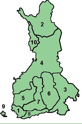
Mapa + English: Numbered map of the historical provinces of Finland.
- Numbers correspond to (Finnish Name/Swedish name):
- Varsinais-Suomi/Egentliga Finland
- Lappi/Lappland (map shows only the part in present-day Finland)
- Karjala/Karelen
- Pohjanmaa/Österbotten
- Satakunta/Satakunda
- Savo/Savolax
- Häme/Tavastland
- Uusimaa/Nyland
- Ahvenanmaa/Åland
- Länsipohja/Västerbotten (map shows only the part in present-day Finland)
- Created, uploaded by User:Elo on the Finnish Wikipedia under GNU-License
+ pochází z Wikimedia Commons, kde má status – Creative Commons Attribution-Share Alike 3.0 Unported license.
Note: The usage of coats of arms is governed by legal restrictions, independent of the copyright status of the depiction shown here.
Historie souboru
Kliknutím na datum a čas se zobrazí tehdejší verze souboru.
| Datum a čas | Náhled | Rozměry | Uživatel | Komentář | |
|---|---|---|---|---|---|
| současná | 31. 7. 2016, 17:20 |  | 275×414 (19 kB) | Sysop (diskuse | příspěvky) | (Znak + + pochází z Wikimedia Commons, kde má status – This file depicts the coat of arms of a Finnish municipality (kunta), district (maakunta) or administrative or historical province (lääni). According to Finnish copyright law and opinion of the) |
- Editovat tento soubor v externím programu (Více informací najdete v nápovědě pro nastavení.)
Odkazy na soubor
Na soubor odkazuje tato stránka:
