Soubor:Liechtenstein topographic map-de Version Tschubby.png
Z Multimediaexpo.cz
(Rozdíly mezi verzemi)
(Fotografie +) |
(+ Doplnění) |
||
| Řádka 1: | Řádka 1: | ||
| - | + | Mapa + Description: | |
| + | * Deutsch: Topographische Karte von Liechtenstein, deutsche Version | ||
| + | * English: Topographic map in German of Liechtenstein | ||
| + | * Français: Carte topographique en allemand du Liechtenstein | ||
| + | * Date: 21 July 2009 | ||
| + | * Source (English): | ||
| + | ** Topographic data from the NASA Shuttle Radar Topography Mission (SRTM3 v.2) (public domain) edited with 3DEM and dlgv32 Pro, and vectorized with Inkscape ; UTM projection ; WGS84 datum ; shaded relief (N-W lightning positions) edited with The Gimp ; | ||
| + | ** Reference used for the additional data : | ||
| + | *** Rivers, cities, railroads, routes, bathymetry : Demis add-on for World Wind (see the approval e-mail and the Demis forum) ; | ||
| + | *** Borders and coast : World data bank II + + File:Liechtenstein-admin.png by user:Aotearoa ; | ||
| + | *** Approximate scale of topographic data : 1:1,463,000 ; | ||
| + | ** Note : The shaded relief is a raster image embedded in the SVG file. | ||
| + | ** Approximate geographic limits of the map (30" close) : | ||
| + | *** SW corner : 47°02'05"N – 9°40'00"E | ||
| + | *** SE corner : 47°02'05"N – 9°70'00"E | ||
| + | *** NE corner : 47°27'55"N – 9°70'00"E | ||
| + | *** NW corner : 47°27'55"N – 9°40'00"E | ||
| + | * Author: Bourrichon, translated by NordNordWest, new Design by Tschubby | ||
| + | |||
| + | {{Cc-by-sa-all}} | ||
| + | [[Kategorie:Maps of Liechtenstein]] | ||
Aktuální verze z 23. 8. 2018, 08:56
Mapa + Description:
- Deutsch: Topographische Karte von Liechtenstein, deutsche Version
- English: Topographic map in German of Liechtenstein
- Français: Carte topographique en allemand du Liechtenstein
- Date: 21 July 2009
- Source (English):
- Topographic data from the NASA Shuttle Radar Topography Mission (SRTM3 v.2) (public domain) edited with 3DEM and dlgv32 Pro, and vectorized with Inkscape ; UTM projection ; WGS84 datum ; shaded relief (N-W lightning positions) edited with The Gimp ;
- Reference used for the additional data :
- Rivers, cities, railroads, routes, bathymetry : Demis add-on for World Wind (see the approval e-mail and the Demis forum) ;
- Borders and coast : World data bank II + + File:Liechtenstein-admin.png by user:Aotearoa ;
- Approximate scale of topographic data : 1:1,463,000 ;
- Note : The shaded relief is a raster image embedded in the SVG file.
- Approximate geographic limits of the map (30" close) :
- SW corner : 47°02'05"N – 9°40'00"E
- SE corner : 47°02'05"N – 9°70'00"E
- NE corner : 47°27'55"N – 9°70'00"E
- NW corner : 47°27'55"N – 9°40'00"E
- Author: Bourrichon, translated by NordNordWest, new Design by Tschubby
+ pochází z Wikimedia Commons, kde má status – This file is licensed under the Creative Commons Attribution-Share Alike 4.0 International, 3.0 Unported, 2.5 Generic, 2.0 Generic and 1.0 Generic license.
Historie souboru
Kliknutím na datum a čas se zobrazí tehdejší verze souboru.
| Datum a čas | Náhled | Rozměry | Uživatel | Komentář | |
|---|---|---|---|---|---|
| současná | 23. 8. 2018, 08:25 | 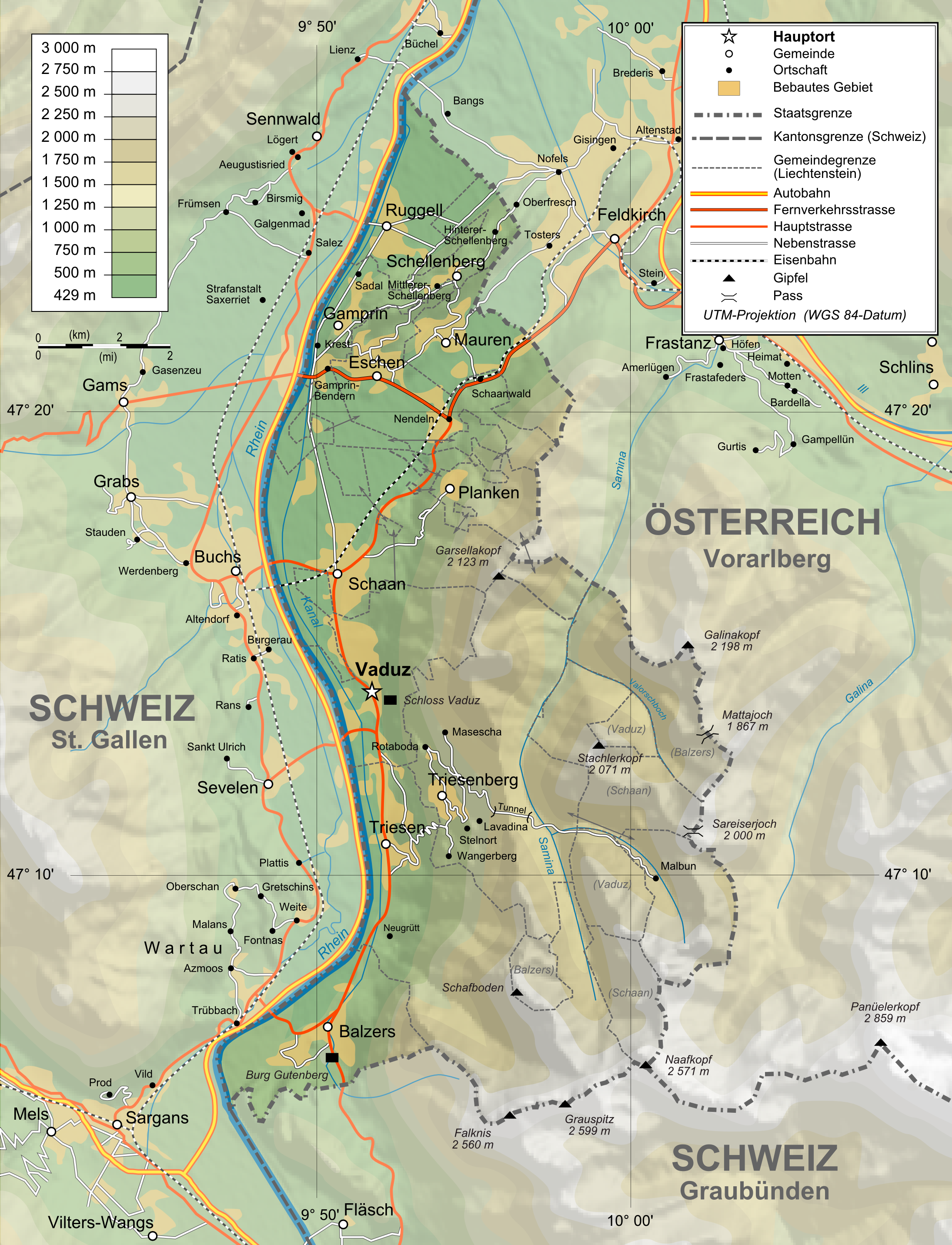 | 2 189×2 862 (2,2 MB) | Sysop (diskuse | příspěvky) | (Fotografie + ) |
- Editovat tento soubor v externím programu (Více informací najdete v nápovědě pro nastavení.)
Odkazy na soubor
Na soubor odkazuje tato stránka:


