V pondělí 16. září 2024 začala naše další
nová soutěž o nejlepší webovou stránku !!
Proto neváhejte a začněte rychle soutěžit o lákavé ceny !!
nová soutěž o nejlepší webovou stránku !!
Proto neváhejte a začněte rychle soutěžit o lákavé ceny !!
Soubor:IrelandNumbered.png
Z Multimediaexpo.cz
(Rozdíly mezi verzemi)
(MW1.15-Fotografie) |
(++) |
||
| (Není zobrazena jedna mezilehlá verze.) | |||
| Řádka 1: | Řádka 1: | ||
| - | + | Mapa + Description: | |
| + | * Map showing the 32 counties of Ireland. | ||
| + | * Author: User Morwen on en.wikipedia | ||
| + | |||
| + | {{GFDL}} | ||
| + | [[Kategorie:Maps of Ireland]] | ||
Aktuální verze z 19. 2. 2023, 18:05
Mapa + Description:
- Map showing the 32 counties of Ireland.
- Author: User Morwen on en.wikipedia
+ pochází z Wikimedia Commons, kde má status – Permission is granted to copy, distribute and/or modify this document under the terms of the GNU Free Documentation License, Version 1.2 or any later version published by the Free Software Foundation; with no Invariant Sections, no Front-Cover Texts, and no Back-Cover Texts.
Historie souboru
Kliknutím na datum a čas se zobrazí tehdejší verze souboru.
| Datum a čas | Náhled | Rozměry | Uživatel | Komentář | |
|---|---|---|---|---|---|
| současná | 13. 4. 2014, 22:32 | 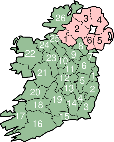 | 400×499 (94 kB) | Sysop (diskuse | příspěvky) | (MW1.15-Fotografie) |
- Editovat tento soubor v externím programu (Více informací najdete v nápovědě pro nastavení.)
Odkazy na soubor
Na soubor odkazuje tato stránka:


