Soubor:Rail gauge world.png
Z Multimediaexpo.cz

Velikost tohoto náhledu je: 800 × 449 pixelů
Obrázek ve vyšším rozlišení (rozměr: 1 425 × 800 pixelů, velikost souboru: 103 kB, MIME typ: image/png)
Obrázek + Description:
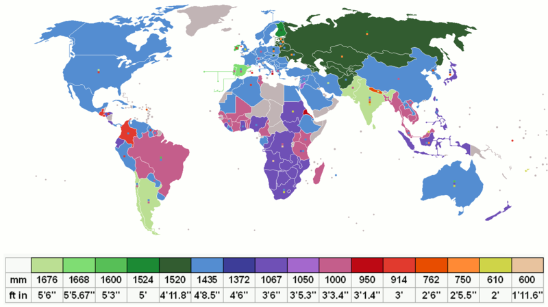
- English: Shows the gauge which is currently most used in each country (main colour), with other significant gauges used depicted as small squares on top of the main colour. Grey indicates no railways.
- Français : Montre l'écartement le plus utilisé dans chaque pays (couleur principale), les autres écartements significatifs sont illustrés par des petits carrés superposés sur la couleur principale. Le gris signifie pas de chemins de fer.
- Español: Muestra la trocha (ancho de vía) más usada en cada país (color principal), con otros calibres significativos como pequeños cuadrados superpuestos sobre el color principal. El color gris indica carencia de ferrocarriles.
- 中文(简体):显示当前在每个国家/地区最常用的规格(主要颜色),其他重要规格在主要颜色顶部显示为小方块。灰色表示没有铁路。
- 中文(繁體):顯示當前在每個國家/地區最常用的規格(主要顏色),其他重要規格在主要顏色頂部顯示為小方塊。灰色表示沒有鐵路。
- Date: 27 November 2006
- Source: Made using the list on CIA Factbook railways and Seabhcan's railmap. Uses File:BlankMap-World-v8.png
- Author: Barrera marquez, RaviC, DePiep, Jackdude101, Rtfroot
+ pochází z Wikimedia Commons, kde má status – Permission is granted to copy, distribute and/or modify this document under the terms of the GNU Free Documentation License, Version 1.2 or any later version published by the Free Software Foundation; with no Invariant Sections, no Front-Cover Texts, and no Back-Cover Texts.
Historie souboru
Kliknutím na datum a čas se zobrazí tehdejší verze souboru.
| Datum a čas | Náhled | Rozměry | Uživatel | Komentář | |
|---|---|---|---|---|---|
| současná | 21. 12. 2024, 14:30 |  | 1 425×800 (103 kB) | Sysop (diskuse | příspěvky) | (Obrázek + ) |
- Editovat tento soubor v externím programu (Více informací najdete v nápovědě pro nastavení.)
Odkazy na soubor
Na soubor odkazuje tato stránka:
